Forest Road 422/Pine Mountain Area
Fast Flight Facts
Target Species: Transition Zone (Pine/Oak) and chaparral/juniper species
Elevation: 5000' -6200'
Habitat: Pine and oak forest, chaparral, juniper, and rocky areas
Overall Birding Rating: 4
Difficulty: 3-5 (Moderate to Very Difficult)
Birding Type: Moderate to very difficult hiking
Facilities: None; Convenient pulloffs for camping overnight
Fees/Ownership: No fees, part of the Tonto National Forest
Closest Town or City/How far from Phoenix: Fountain Hills/ 45 miles northeast of Phoenix
Getting there: Accessed from Forest Road 143 (main road to Four Peaks) on a well signed pulloff to the west. Forest Road 422 can only be done with a high clearance vehicle.
Overview: Forest Road 422 (signed off as "Mazatzal Divide Trail" on online maps) is found in a remote section of the Mazatzal Mountains. This route is rough, is a 4x4 road, and requires a high clearance vehicle, and is accessed a few miles north of the traihead that takes hikers to the summits of Four Peaks. Forest Road 422 is well signed and branches off to the west from Forest Road 143, which is the main road up and down Four Peaks. Once on this road, it heads north for over ten miles through the remote wilderness, between the tall mountainsides of Mount Ord to the north and the towering Four Peaks to the south. Most of Forest Road 422 is very rough, and it requires a high clearance vehicle with four wheel drive being highly a highly recommended source. The habitat is wonderful along this road, and takes the birder through great ponderosa pine and oak habitat as the best habitat selection. Along the Mazatzal Divide Trail, a large percentage of the forests are found on north-facing mountainsides, which have lush habitat and towering ponderosa pines. As with most Transition Zones in Maricopa County, Forest Road 422 is constantly close to the Maricopa and Gila County lines, which cross over each other multiple times.
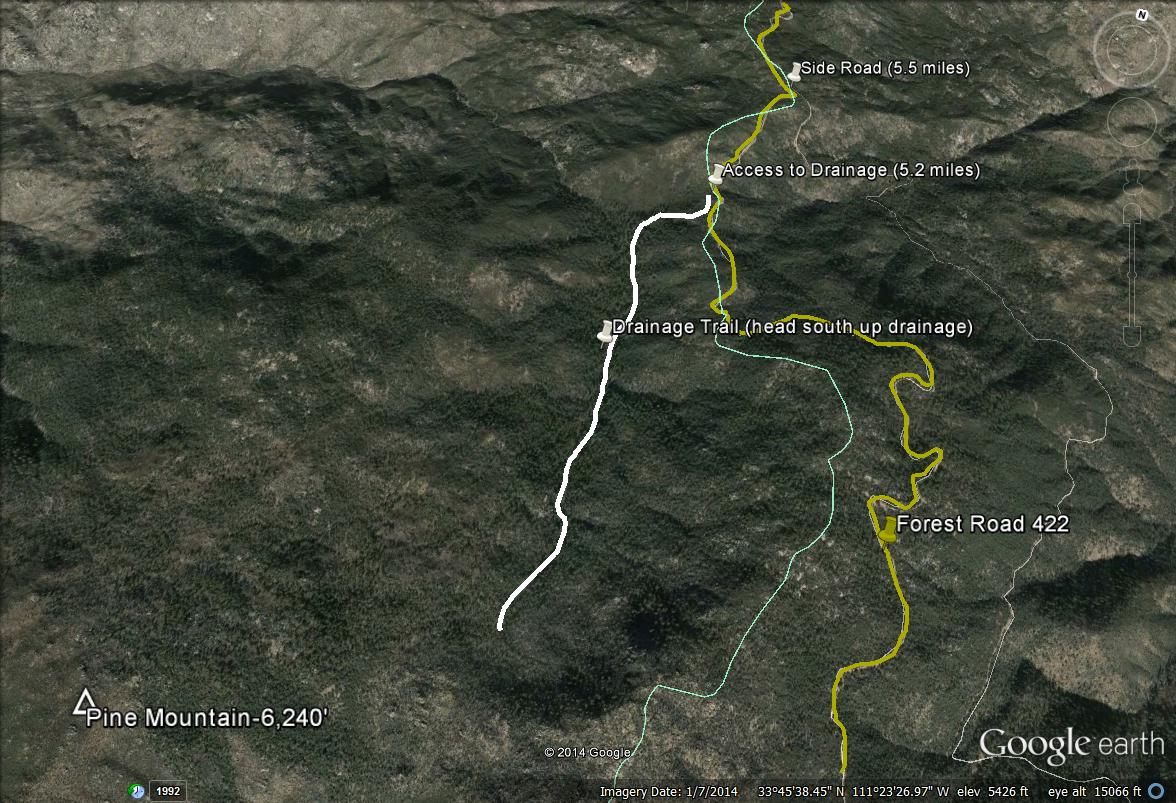
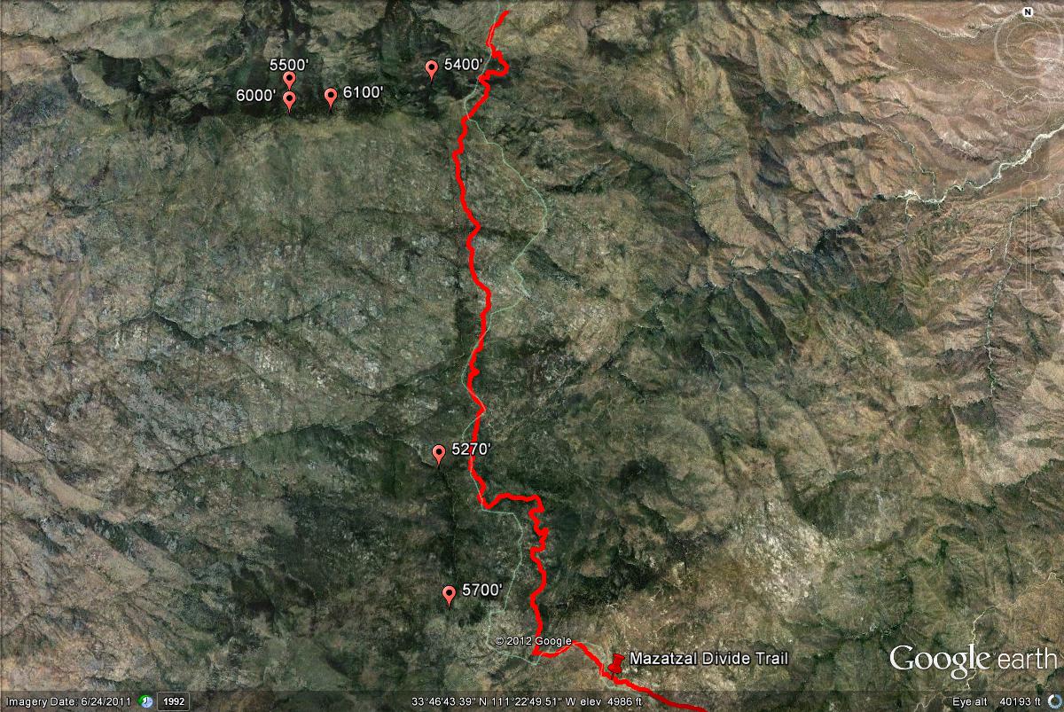
The best area to bird along Forest Road 422 is at Pine Mountain, where there is a very attractive and big section of ponderosa pine and oak forest on a north-facing slope that is entirely in Maricopa County. This area is accessed by hiking up a drainage that can be reached after driving for the first 5.2 miles of the Mazatzal Divide Trail, on the west side of the road through a fence opening. This drainage heads up on the heavily forested north-facing Pine Mountain, and this section can be explored by taking the drainage up through the forest towards Pine Mountain, which is over 6200' in elevation. After finding the fence opening, there is a trail that leads down to the drainage, and the trail eventually travels along the dranainge and up in the direction of Pine Mountain. This trail is very convenient, and is marked in progress by stacked-up-rocks, which may be part of a trail system. It crosses over the drainage often and explores both sides, which makes the birding very interesting. A gradual climb is accomplished when hiking up the drainage (which is about a one mile hike), in elevation ranges from 5270' to almost 5700'. Eventually, the trail climbs out of the drainage and travels up in the direction of Pine Mountain. Pine Mountain and it's surroundings are covered with thick timber and towering ponderosa pines. Plenty of oaks are on the mountain too, and the habitat is very thick and shady in parts. Because of Pine Mountain's thick habitat, most of it is very difficult to navigate through other than when sticking to the trail and hiking within the drainage. The drainage itself is a very difficult walk. Interestingly, this mountain area is cooler than most in Maricopa County due to the fact it is on a north-facing mountain. It is cool, humid and moist, and a majority of rocks on the drainage are covered in moss.
Bird diversity is similar at Pine Mountain and Forest Road 422 in general to the other Transition Zones found in Maricopa County. The fact that much of the forest habitat in the area is on a north-facing slope can make a huge difference. In the pine and oak forests, birds typical of the habitat include Zone-tailed Hawk, Band-tailed Pigeon (with some luck), Anna's and Broad-tailed Hummingbirds, Acorn and Hairy Woodpeckers, Northern Flicker, Western Wood-Pewee, Plumbeous and Hutton's Vireo, Bridled and Juniper Titmouse, White-breasted Nuthatch, Bewick's Wren, Olive, Grace's, Virginia's, and Black-throated Gray Warblers, Painted Redstart, and Hepatic Tanager. Owling at night has produced Elf Owl, Western Screech-Owl, and Northern Saw-whet Owl. Dusky-capped Flycatchers have also been found, a scarce species in Maricopa County that already breeds at Slate Creek Divide. Birds found in chaparral and juniper habitats surrounding these forests include Gray Vireo, Western Scrub-Jay, Bushtit, Blue-gray Gnatcatcher, Spotted Towhee, and Black-chinned Sparrow.
Continuing on Forest Road 422, another forested area in Maricopa County can be found about a mile west of the west side of the road at about 8 miles, which is on the north-facing side of Boulder Mountain. Boulder Mountain is extremely difficult to access, and it's upper reaches have stands of ponderosa pine and some Douglas fir. It is about a mile from the north-west of the road, and access to the forest requires some extremely difficult hiking beforehand through dense and sharp chaparral habitat for over a mile. This stretch of forest is smaller than others, but does look very interesting. This area has probably yet to see any birders, but exploring it may be worth it.
Other than the pine and oak forests, other habitats are excellent in this area also. These habitats consist of chaparral, juniper and pinyon pine, as well as rocky areas.
Birding Tip: First and most importantly, DO NOT explore this area alone. The Four Peaks Wildnerness Area is as remote as most places get, and with this area being a road accessed from Four Peaks and traveling north from there on a high clearance 4X4 road, many dangers and hazards are possible. There is limited help in remote areas like this, so come prepared incase of an emergency. Birding wise, the entire stretch has very good birding. If one's hiking limitations can't go into thick drainages and hike in rough spots, the road offers good birding. Most of the time, as mentioned before, the road follows the county line (but is mostly in Gila County), with Maricopa County being on the western half and Gila County being on the eastern half. There are several branchoff roads from the Forest Road 422 that may have interesting birding, but are in Gila County. Once turning on Forest Road 422, good forest habitat begins at about three miles along the road. At about 5.2 miles, look for a fence opening on the west side of F.R. 422 (there are some areas with fences along the route). There is a trail that leads down into the forested drainage that heads up in the direction of Pine Mountain, which is mentioned above from here. Follow this trail down into the area of the drainage, which is easy to follow. The habitat surrounding the trail is thick before the drainage is reached. One will be led down into a stand of tall pines from the start of this trail. Go west through the pines on the trail (which isn't distinctively marked at this point) a short distance to the drainage, which is very easy to follow. If one has trouble finding this trail and fence opening, a good marker is that there is a noticeable side road that branches off from the 422 just north of the trail opening. This road goes in the southeast direction in Gila County for a good distance and is not recommended for driving. After exploring or passing this 5 mile mark on the 422, continue north to explore more of the Mazatzal Divide, including the other forested mountainside west of the road at about 8 miles if one is brave enough. To get a better overview of this area, look under the maps page on the "Pages" section below.
Directions: From the intersection of Shea Boulevard and the Beeline Highway, head north on Highway 87 (Beeline Highway) for 14 miles. Forest Road 422 is accessed from Forest Road 143, also known as the Four Peaks Road or the road to Four Peaks. The turnoff to Four Peaks is on the east side of Highway 87, between mile markers 203 and 204. Mile marker 204 is barely north of the Four Peaks turnoff. After turning, the road to Four Peaks is called Forest Road 143. Forest Road 143 runs for almost 18 miles until the turnoff to the Lone Pine Saddle is reached in the Transition Zone, that heads south. From here, head north for two to three miles until the turnoff to Forest Road 422 is reached. Turn west on Forest Road 422 and head north to explore the area. An alternative route would be to take Forest Road 143 from Highway 188 for about ten miles until Forest Road 422 is reached. Coming up Forest Road 143 from Highway 188 through Gila County is much easier on vehicles than taking Forest Road 143 from Highway 87 through Maricopa County. For additonal directions on finding things along the Mazatzal Divide Trail/Forest Road 422, look under the Birding Tip and maps under Pages for this area.
Pages:
Scenes and Sights from Forest Road 422/Pine Mountain Area:
Views of Pine Mountain (above and below)
Birdlife of Forest Road 422/Pine Mountain Area:
Painted Redstart
Gray Vireo
Elf Owl
Dusky-capped Flycatcher (rare in Maricopa County)
Hairy Woodpecker
This page was made possible by T.J. Knupp, the backcountry travel king..
Forest Road 422/Pine Mountain Area Maps
*All maps property of Google.
Map # 1: Getting to Forest Road 422.
From the intersection of Shea Boulevard and the Beeline Highway, head north on Highway 87 (Beeline Highway) for 14 miles. Forest Road 422 (titled Mazatzal Divide Trail on some maps) is accessed from Forest Road 143, also known as the Four Peaks Road or the road to Four Peaks. The turnoff to Four Peaks is on the east side of Highway 87, between mile markers 203 and 204. Mile marker 204 is barely north of the Four Peaks turnoff. After turning, the road to Four Peaks is called Forest Road 143. Forest Road 143 runs for almost 18 miles until the turnoff to the Lone Pine Saddle is reached in the Transition Zone, that heads south. From here, head north for two to three miles until the turnoff to Forest Road 422 is reached. Turn west on Forest Road 422 (Mazatzal Divide Road) and head north to explore the area. An alternative route would be to take Forest Road 143 from Highway 188 for about ten miles until Forest Road 422 is reached. Coming up Forest Road 143 from Highway 188 through Gila County is much easier on vehicles than taking Forest Road 143 from Highway 87 through Maricopa County.
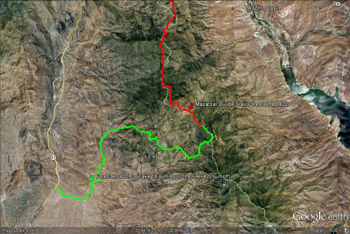
Map # 2: Accessing Forest Road 422 "Mazatzal Divide Trail/Road"
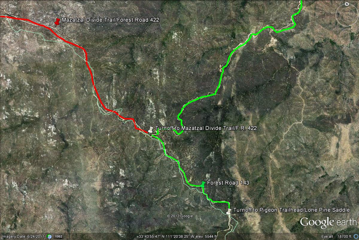
Map # 3: Overview of the Forest Road 422 and mile points.
Once turning on Forest Road 422 "Mazatzal Divide Trail", good forest habitat begins at about three miles along the road. At about 5.2 miles, look for a fence opening on the west side of F.R. 422 (there are some areas with fences along the route). There is a trail that leads down into the forested drainage up in the direction of Pine Mountain. Follow this trail down into the area of the drainage, which is easy to follow. The habitat surrounding the trail is thick before the drainage is reached, one marking their path every 50 feet is a good idea to prevent searching for the trail in the dense habitat. One will be led down into a stand of tall pines from the start of this trail. Go west through the pines on the trail (which isn't distinctively marked) a short distance to the drainage, which is very easy to follow. If one has trouble finding this trail, a good marker is that there is a noticeable side road that branches off from the 422 just north of the trail opening. This road goes in the southeast direction in Gila County for a good distance and is not recommended for driving. After exploring or passing this 5 mile mark on the 422, continue north to explore more of the Mazatzal Divide, including the other forested mountainside west of the road at about 8 miles.
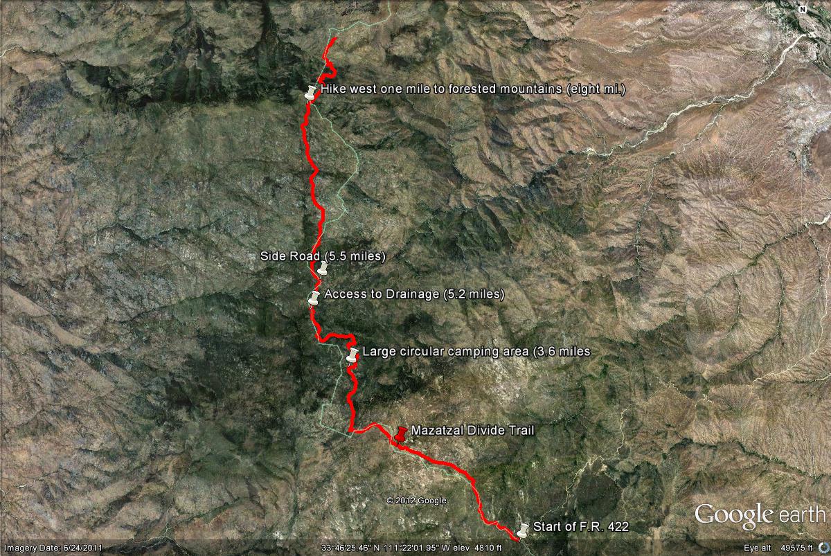
Here is a photo of the fence opening to access the trail that leads down to the drainage.
Map # 4: A closer look at accessing the drainage near Pine Mountain.
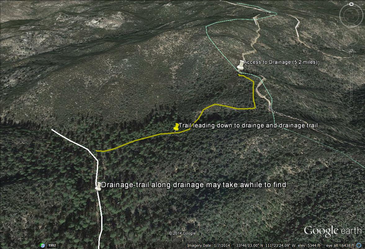
Map # 5: Overview of the Pine Mountian Area
Map # 6: Great forested areas along Forest Road 422 "Mazatzal Divide Trail" that are in Maricopa County.
No comments:
Post a Comment